新型工具助你成为海洋探险家-石油圈
| 所在地区: | 四川-- | 发布日期: | 2019年8月6日 |
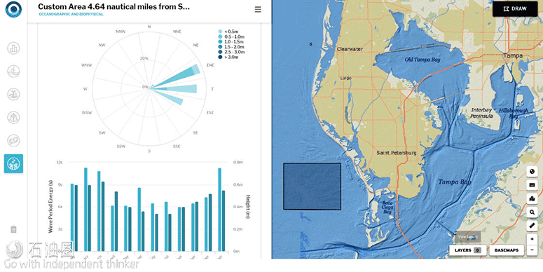
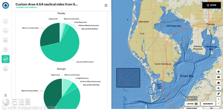
摘要:NOAA的新型OceanReports工具基于网页、以报告为核心,直击沿海与海洋规划者们的痛点,为他们提供了高水平分析。 编译:大安 TOM 内政部海洋能源管理局(BOEM)与商务部国家海洋和大气管理局(NOAA)合作创建了这一新的、基于网页的海洋测绘与规划交互工具。无论你是海洋从业人员,还是海岸管理者,或是学生,甚至是普通大众,利用该工具你就有机会在自己的电脑上,成为一名海洋探险家。 新的OceanReports网页版工具通过即时分析100多个海洋数据集,为用户提供了专门的“海洋邻域分析”,包括地图与图形。该工具可提供丰富的总结统计与信息图,涵盖六大主题:基本信息、能源与矿产、自然资源与保护、海洋学与生物物理学、运输与基础设施、经济与商业。 美国海域面积近400万平方英里,是世界上最大的专属经济区(EEZ)之一。如今,当您使用OceanReports应用程序浏览美国专属经济区的任何区域时,您可以获得有关栖息地与物种、正在作业的行业、潜在危险(如海底电缆或沉船)、海洋商业的经济价值、海洋学信息等详尽信息。 美国国家海洋局代理局长Neil Jacobs博士说:“现在可以利用世界上最大的‘海洋情报库’,来帮助维持与发展世界上最大的蓝色经济体之一。无论是水产养殖选址、海洋运输还是近海能源,OceanReports都能将这些数据置于我们的指尖,在发展国民经济的过程中,为我们提供优势。” OceanReports以十多年的数据收集为基础,将看似不相干的海洋信息整合起来,服务于国内的海洋与沿海产业,为国家经济增加了3200亿美元的国内生产总值。 使用OceanReports,您可以同时访问100多个NOAA数据集,来全面了解美国专属经济区的任何区域。在这里,您能够轻松查阅佛罗里达州圣彼得堡附近海域的海洋经济数据。(NOAA) OceanReports不仅为工业与科学提供了数据源泉,而且也可应用于课堂上,帮助学生们学习生物学、化学、地理学以及其他学科,如经济学。 BOEM代理主管Walter Cruickshank表示:“在复杂的海洋环境中,存在着海洋资源开发与利益相关者的多样性,OceanReports工具可大幅提高人们理解与管理海洋资源的能力。” 特点 1、可用于快速参考与场地描述; 能源行业利用这些数据 1)定位海上基础设施,例如沿海能源设施、海洋水力发电项目与风力发电厂; OceanReports对所有海洋产业来说是一个里程碑式的进步。水产养殖等新兴产业,以及能源与航运等现有产业都将受益。所有人都能够轻松获取前所未有的、海量的海洋情报。如今,每个人都将获得更详尽的信息、更精准的定位,以保护海洋资源,并可将海洋贸易发展到新的水平。 Overview Features Use these data to 1) locate offshore infrastructure such as coastal energy facilities, marine hydrokinetic projects, and wind farms, and 2) determine the best sites for offshore energy facilities using information about oil and gas resource plays, deepwater ports, ocean energy resource potential, offshore wind mission compatibility assessments, offshore wind technology depth zones, and others. A new, web-based interactive tool for ocean mapping and planning created by the Department of the Interior’s Bureau of Ocean Energy Management (BOEM) and the Department of Commerce’s National Oceanic and Atmospheric Administration (NOAA) will give everyone from ocean industries to coastal managers, students, as well as the general public, the opportunity to be an ocean explorer right from their own computer. The new OceanReports web tool provides users specialized “ocean neighborhood analyses” including maps and graphics by analyzing more than 100 ocean datasets instantaneously. U.S. ocean waters comprise nearly four million square miles and are one of the largest Exclusive Economic Zones (EEZ) in the world. Now, when you outline any area in the U.S. EEZ using the OceanReports app, you can get detailed information about habitats and species, industries at work, potential hazards such as undersea cables or shipwrecks, economic value of ocean commerce, and detailed oceanographic information. OceanReports builds on more than a decade of data collection to transform how seemingly disparate ocean information can be delivered to the nation’s ocean and coastal industries, which add $320 billion in gross domestic product to the nation’s economy. Tu 2 Using OceanReports, you can tap into more than 100 NOAA datasets at once for any part of the U.S. Exclusive Economic Zone. Here, you can see ocean economic data for communities near St. Petersburg, Florida. (NOAA) And while OceanReports provides a fountain of data for use by industry and science, it is still easy enough to use in the classroom to help students studying biology, chemistry, geography and even other disciplines like economics. “With such a diverse range of ocean uses and stakeholders, the OceanReports tool greatly increases one’s ability to understand and manage the resources in the complex ocean environment,” said BOEM acting director Walter Cruickshank. “Our team worked diligently with NOAA to create this tool, which benefits the ocean community in addition to helping BOEM carry out its mission — the responsible development of ocean energy and marine mineral resources for the nation.” “OceanReports is a monumental advancement for all ocean industries,” said James Morris, NOAA marine ecologist and member of the OceanReports development team. “New industries such as aquaculture and existing industries such as energy and shipping will all benefit from having easy access to this unprecedented volume of ocean intelligence. Everyone will now be better informed and positioned to conserve marine resources and grow ocean commerce to new levels.”
BOEM与NOAA共同努力,合作创造出这个工具。这不仅有利于海洋界,而且有助于开发海洋能源与海洋矿物资源。
2、收集了六大主题的高级统计数据与信息图表;
3、针对感兴趣的自定义区域,生成、打印与共享报告。
2)利用油气藏、深水港、海洋能源资源、海上风电兼容性评估、海上风电技术可用水深等相关信息,确定海上能源设施的最佳地点。
This web-based, report-centric tool provides coastal and ocean planners with a high-level analysis for their custom-drawn area of interest. It provides summary statistics and infographics for six main topics: general information, energy and minerals, natural resources and conservation, oceanographic and biophysical, transportation and infrastructure, and economics and commerce.
Use for quick reference and site characterization
Gather high-level statistics and infographics on six themes
Generate, print, and share reports for a custom area of interest
“The world’s largest collection of ‘ocean intelligence’ can now be accessed to help sustain and grow one of the world’s largest blue economies,” said Neil Jacobs, Ph.D., acting NOAA administrator. “Whether it’s aquaculture siting, marine transportation, or offshore energy, OceanReports puts this data at our fingertips and gives us an edge as we continue to grow our national economy.”
按照客观、公正、公开的原则,本条信息受业主方委托独家指定在中国建设招标网 www.jszhaobiao.com 发布
注册会员 享受贴心服务
标讯查询服务
让您全面及时掌握全国各省市拟建、报批、立项、施工在建项目的项目信息。
帮您跟对合适的项目、找对准确的负责人、全面掌握各项目的业主单位、设计院、总包单位、施工企业的项目 经理、项目负责人的详细联系方式。
帮您第一时间获得全国项目业主、招标代理公司和政府采购中心发布的招标、中标项目信息。
标讯定制服务
根据您的关注重点定制项目,从海量项目中筛选出符合您要求和标准的工程并及时找出关键负责人和联系方式。
根据您的需要,向您指定的手机、电子邮箱及时反馈项目进展情况。