3年间风生水起 这家物探公司靠哪些“宝藏”技术?-石油圈
| 所在地区: | 广西-河池-大化县 | 发布日期: | 2020年12月2日 |
近期,Shearwater公司展示了其在地球物理领域的代表性核心技术。
编译 | 二丫
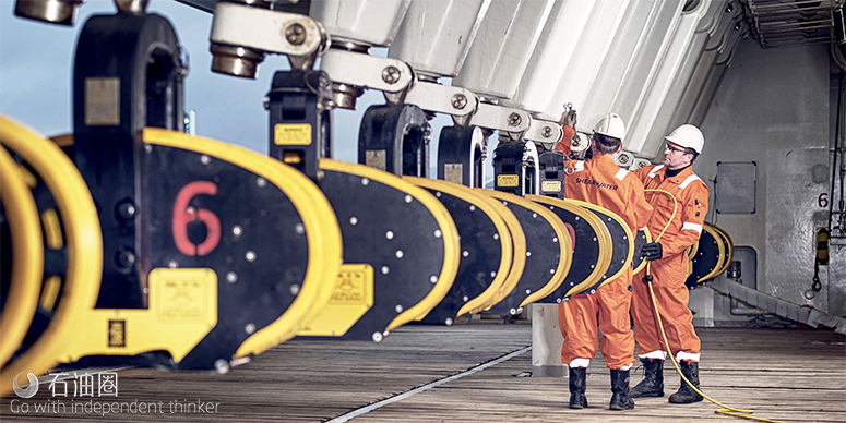
2016年,地震服务市场一片萧条,老牌公司纷纷转向船舶制造、部门重组,想要在该行业有史以来最糟糕的市场环境中竭尽全力的生存下来。虽然其他公司正努力降低成本,来应对经济衰退的严峻考验,但新成立的Shearwater公司召集了经验丰富的管理团队,打造出一只拥有四艘现代化高性能船舶、专有数据处理与成像软件的精兵队伍,并且GC Rieber公司与RASMUSSENGRUPPEN AS公司也成为其坚实的后盾。
2016年10月,GC Rieber Shipping ASA与RASMUSSENGRUPPEN AS签署协议,共同成立Shearwater GeoServices AS海洋地球物理公司,并由其接管四艘大容量地震船Polar Empress,Polar Duke,Polar Duchess和Polar Marquis。组建完成前后,该公司即相继与TGS、WGP、挪威石油管理局、ONGC等客户签署服务协议。
2018年11月,Shearwater完成了对油服巨头斯伦贝谢的海上地震采集资产及其地球物理产品线WesternGeco业务的收购。
2019年以来,Shearwater进一步与Aker BP、挪威国油、TGS、CGG签署了服务/合作协议,并于今年5月宣布与挪威国油共同开发海洋地震震源技术。
近日,Shearwater梳理了其部分具有代表性的海洋地震核心技术。
Qmarine点接收海洋地震系统
Qmarine点接收海洋地震系统于2000年投入使用。该系统拥有凝胶填充的固体拖缆、声学定位等海上组件、可降低噪音与阻力的拖缆控制设备。它采用单传感器记录噪声,具有较高的分辨率,可以在不影响信号带宽与保真度的前提下,利用针对性的数字滤波技术去除噪声。Qmarine系统还通过引入QFin海洋地震拖缆转向系统,开创了可转向拖缆的先河。QFin系统的遥控转向装置设计用于降低噪音,并可实现精确的深度控制与水平转向。拖缆的水平转向可提供拖缆安全分离控制、扇状地震勘探、用于优化覆盖率的主动转向。后来的改进包括可控制方向的震源与QPilot控制系统,该系统集成了所有拖缆命令与控制功能,以优化4D地震的可重复性。
Isometrix海上等距地震技术
Isometrix是一种海上等距地震技术,它可记录更多测量数据,以建立各方位、详细的地震波场图。与其他传统拖缆采集技术相比,它填补了拖缆之间的缺失数据,这将直接提高各方位的微观尺度分辨率,从而能够更准确地表观出地下地质情况。该系统的另一个优点是,在不影响数据质量的前提下,可以通过拖拽更少、间隔更远的拖缆,来增加勘探的覆盖面积。
该技术的核心是一种地震拖缆,它将标准水听器(P)的测量数据,与垂直(Z)、交叉线(Y)方向上用来记录地震压力梯度的两个加速度传感器的数据相结合。双传感器(PZ)测量值可实现接收器的反虚反射,但Isometrix将三种PZY测量值整合起来,可以实现三维的反虚反射,并重建拖缆之间的地震波场。该技术从所有三个方向(垂直、沿拖缆、拖缆间交叉线方向)提供了真正的宽波段结果。
密集的传感器具有强大的数据预处理与杂波抑制能力,再加上采集系统中实时进行的单传感器数字处理,从而能够产生高质量的现场数据,为进一步的处理与成像做好充足准备。
得益于这些高质量的测量值,插值法与三维反虚反射成为可能。以东非海上的深水前沿勘探区为例(下图),左图为重建出的实际两个相邻拖缆之间、虚拟间隔范围内的上行地震波场。
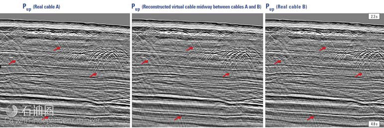
即使在应用反虚反射与消泡程序之前,这些部分也已经显示出高质量、宽波段数据的特征。在实际拖缆A与B之间的虚拟拖缆间距,尽管存在100 m的拖缆间距,但仍能正确捕获诸如差异(如图所示)之类的复杂事件,这表明Isometrix技术在处理流程的早期,就能够在发射器范围内精确地插值。
Qseabed单传感器采集系统
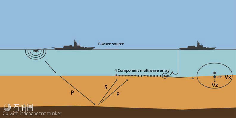
海底地震(OBS)采集是地震市场中一个蓬勃发展的领域,包括海底节点(OBN)与海底电缆(OBC)方法,这两种方法都需要将地震传感器直接部署在海床上(下图)。Shearwater公司为各种环境与水深提供海底解决方案,包括Q-Seabed多分量OBC系统与海底节点系统,或两种技术的组合。
通常,在受限于地质、环境或当地油田基础设施条件的区域,无法使用单一手段或技术实现最优覆盖,也可组合使用拖缆与OBS采集技术。这种方法可由该公司的三艘多用途地震船提供。
Qseabed是一个单传感器采集系统,带有完全校准的水听器与三分量加速度计。该系统能够同时记录多达四根电缆,每根电缆的最大有效长度为30 km,额定深度为1,500 m,并且基于多船只同时作业,可实现滚动扩展。该系统拥有灵活的测量选项,从而提高效率,同时实现最大化叠加。
在获得了高质量的原始地震资料后,利用地震资料分析系统进行先进的数据处理与成像。
Reveal处理与成像软件
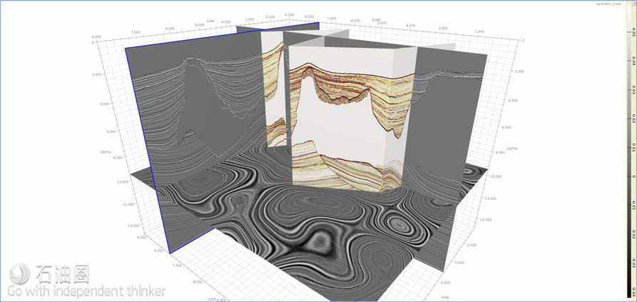
在同一个用户界面内,Reveal处理与成像软件就可执行海洋与陆地地震数据的基于时间和深度的处理与成像(下图)。在油田、油气公司的大型数据中心或客户的数据中心,这个完备的处理平台设计用于笔记本电脑。凭借先进的批量作业管理、并行处理以及集群可扩展性,地球物理学家利用Reveal软件可实现快速的数据回看。而且,可以直接从现场磁盘、SEGYs或其他格式读取数据,并在任何有连接的地方进行处理。Reveal还为给开发人员提供了开源环境,客户能够将Reveal与自己的软件、工作流程以及处理系统集成在一起。
该系统的海洋处理模块为任何海洋地震处理任务都提供了一系列工具。首先,可以选择在地震船上执行实时质量控制、二维与三维表层相关多次波衰减(SRME)、叠前时间偏移(PSTM)以及先进的深度成像。
同样,陆上处理工具涵盖了从折射静力学到最终时间和深度成像的所有方面。这些计算密集型的陆地工具启用了消息传递接口(MPI),这意味着曾经局限于一台机器的计算解决方案,可以在整个集群中进行划分。此外,该系统的高级陆上功能包括最新的算法,如5D插值、3D去噪、发射器自动重新定位等。
Reveal的深度处理工具包括模型构建、基尔霍夫PSDM、逆时偏移(RTM)、层析成像以及全波形反演(FWI)。
该系统完全是为21世纪新一代年轻的专业地球科学家与开发人员设计的,这些人要求软件需具备:功能强大的工具、直观的用户界面与及时的结果。它在不断发展,使地球科学家能够做出更快、更准确的决定。
结论
尽管地震行业经历了最严重、最长时间的低迷,但很明显,该行业保持了研究与创新的活力。通过适应日益萎缩的商业环境,Shearwater公司做到了这一点,使其技术研发能力,始终领先于勘探与开发(E&P)客户不断增长的需求。
地震服务商们将业务聚焦于各自的核心优势,重大的重组与整合都起到了一定作用。但是,地震行业想要继续开发产品以改善石油采收率并描绘出愈发复杂的地质结构,则需加强协作创新的能力。那些能够从地震技术投资中获得最大价值的勘探开发公司,将会成为与地震服务商协作研发新技术的合作伙伴。
In 2016, the demand for seismic services was low and the established players were laying up vessels, restructuring and fighting to survive the worst market conditions the industry had ever experienced. While other companies struggled to reduce costs to meet the rigours of the extended downturn, the newly formed Shearwater brought together an experienced management team to forge a lean organisation with four modern high-capacity vessels, proprietary data processing and imaging soft ware and two solid backers in the form of GC Rieber and RASMUSSENGRUPPEN AS.
Towed streamer acquisition
The Qmarine point-receiver marine seismic system was launched in 2000. Comprising a gel filled solid streamer, all in-sea components such as acoustic positioning and streamer control devices are integral to the streamer, which reduces noise and drag. It uses single-sensor recording to record noise with suff icient resolution to enable it to be removed using targeted digital filtering techniques without aff ecting the signal bandwidth or fidelity. The Qmarine system also pioneered steerable streamers by introducing the QFin marine seismic streamer steering system. The QFin system’s remote-controlled wings are designed to reduce noise and enable both precise depth control and horizontal steering. Horizontal streamer steering provides feather correction, safe streamer separation control, fan-mode shooting, and active steering for optimal coverage. Later refinements included steerable sources and the QPilot control system, which integrates all of the streamer command and control functions to optimise 4D repeatability.
Isometric seismic technology
Isometrix is a marine isometric seismic technology that records additional measurements to build a detailed picture of the seismic wavefield in all directions, filling the gaps between the streamers associated with other conventional towed-streamer acquisition technology. This translates directly to a fine-scale resolution of the subsurface in all directions, enabling a more accurate representation of the subsurface geology. An additional benefit of the system is that subsurface coverage can be increased by towing fewer streamers spaced further apart without compromising data quality.
At the core of this technology is a seismic streamer that combines standard hydrophone (P) measurements with those from two accelerometer sensors recording the seismic pressure gradient in the vertical (Z) and crossline (Y) directions. Dual sensor (PZ) measurements enable receiver deghosting, but Isometrix combines the three PZY measurements to perform 3D deghosting and reconstruction of the seismic wavefield between the streamers. This provides true broadband product in all three directions; vertically, along the streamer and crossline between the streamers.
With powerful data preconditioning and noise attenuation enabled by densely spaced sensors, coupled with single-sensor digital processing that is performed in real time in the acquisition system, high-quality field data is produced that is ready for further processing and imaging.
The quality of these measurements enables joint interpolation and 3D deghosting. The example from deepwater frontier exploration acreage off shore east Africa (Figure 1) shows the upgoing seismic wavefield on the left is successfully reconstructed at two neighbouring real streamers as well as at a virtual streamer midway between the two.
These sections already display the characteristics of high quality broadband data, even before deghosting and debubble routines are applied. Complex events such as diff ractions (as indicated) are correctly captured at the virtual streamer midway between the real streamers A and B, despite the 100 m streamer separation, demonstrating the ability of the Isometrix technology to accurately interpolate in the shot domain early in the processing flow.
Ocean bottom seismic
Ocean bottom seismic (OBS) acquisition is a rapidly growing area of the seismic market, comprising ocean-bottom node (OBN) and ocean-bottom cable (OBC) approaches, both of which entail deploying seismic sensors directly on the seabed (Figure 2). Shearwater off ers seabed solutions for a range of environments and water depths, including the Q-Seabed multicomponent OBC system and nodal options, or a combination of both techniques.
Hybrid combinations of both towed-streamer and OBS acquisition are oft en also used for areas where the geology, environment or local oilfield infrastructure do not allow optimal coverage using a single technique or technology. This approach is provided by the company’s three multipurpose seismic vessels.
Qseabed is a single-sensor acquisition system with fully calibrated hydrophones and three-component accelerometers. With the ability to record from up to four cables simultaneously, each with a maximum active length of 30 km and a depth rating of 1500 m, and multi-vessel operations to enable rolling spreads, the system allows for flexible survey design options that improve eff iciency while maximising fold.
Having acquired high quality raw seismic data, advanced data processing and imaging is performed with the Reveal seismic data analysis system.
Data analysis
Reveal processing and imaging soft ware performs time and depth processing and imaging of marine and land seismic data within a single user interface (Figure 3). This full processing platform is designed to run on laptops in the field, in the company’s own large data centres or in those of its clients. With its advanced batch job management, parallel processing and cluster scalability, geophysicists can achieve rapid turnarounds. Data can be read directly from field tapes, SEGYs or other formats and processed wherever there is connectivity. Reveal also provides a developers’ environment for clients keen to integrate it with their own soft ware, workflows and processing systems.
The system’s marine processing modules off er a range of tools for any marine seismic processing task. This starts with the option to perform real time QC onboard a seismic vessel, 2D and 3D surface related multiple elimination (SRME), pre-stack time migration (PSTM) and advanced depth imaging.
Similarly, the land processing tools cover all aspects of land processing from refraction statics to final time and depth imaging from datum. These computer intensive land tools are message passing interface (MPI) enabled, which means computing solutions that were once constrained to a single machine can be divided across a whole cluster. In addition, the system’s advanced land functionality includes the latest algorithms such as 5D interpolation, 3D de-noise and automatic shot re-location.
Reveal’s depth processing tools comprise model building, Kirchhoff PSDM, reverse time migration (RTM), tomography and full waveform inversion (FWI).
Kirchhoff PSDM
The model building algorithms allow velocity models to be tied to well measurements, horizons manipulated and geobodies visualised (Figure 4). Reveal’s Kirchhoff PSDM is a true amplitude anisotropic migration that uses wavefront reconstruction travel times selected by user driven criteria such as first arrival or minimum velocity contrast. It is ideally suited to moderately complex geology with strong lateral velocity changes.
RTM
Reveal’s RTM is its most advanced depth imaging algorithm. It can perform illumination studies, create angle gathers, filter artifacts and model wavefields (Figure 5). It is well suited for areas where the geology has rapid or sudden lateral changes in velocity that cause significant distortion of the wavefield, and its use of the two-way wave equation allows clear imaging below even the most complex overburdens. It also incorporates a RTM runtime calculator to estimate compute needs.
The tomography tool provides grid-based reflection tomography with automatic and interactive picking methods, together with the ability to estimate anisotropic parameters and Q, the quality factor used to characterise the attenuation of seismic waves in the subsurface.
FWI
FWI is an iterative tomographic technique driven directly by diff erences between true seismic data and synthetic data derived from an estimated earth model (Figure 6). All modelling is performed using the two-way wave equation which leads to a much greater resolution in the inverted model compared that achieved with conventional ray-based tomographic algorithms.
Reveal’s FWI is fully integrated within its platform enabling easy incorporation into larger model-building workflows. For example, intermediate output models can be easily used to test for gather flattening as the inversion proceeds.
Flexibility
Reveal can also be provided on a license basis for use within other development environments. The Python, C++ and Java application program interface (API) gives users the flexibility to develop and incorporate their own algorithms within Reveal and to run their own code eff iciently.
The system has been designed and built entirely in the 21st century for a new wave of young professional geoscientists and developers who demand state-of-the-art soft ware with powerful tools, an intuitive user interface and instant results. It is constantly evolving to allow geoscientists to make faster and more accurate decisions.
Conclusion
Despite the deepest and most prolonged downturn the seismic sector has ever experienced it is clear that the industry has kept research and innovation alive. It has done this by adapting to a diminished business environment in such a way that has enabled technology development to stay ahead of the ever-growing demands of its exploration and production (E&P) customers.
Seismic contractors re-focussing their businesses around their individual core strengths, significant re-structuring and consolidation have all played a part. But perhaps the biggest factor behind the seismic industry’s continuing ability to develop products to improve oil recovery and to image ever more complex geological structures will be the ability to innovate collaboratively. The E&Ps who obtain the most value from their seismic investments will be those who collaborate with vendors to generate new technology.
按照客观、公正、公开的原则,本条信息受业主方委托独家指定在中国建设招标网 www.jszhaobiao.com 发布
注册会员 享受贴心服务
标讯查询服务
让您全面及时掌握全国各省市拟建、报批、立项、施工在建项目的项目信息。
帮您跟对合适的项目、找对准确的负责人、全面掌握各项目的业主单位、设计院、总包单位、施工企业的项目 经理、项目负责人的详细联系方式。
帮您第一时间获得全国项目业主、招标代理公司和政府采购中心发布的招标、中标项目信息。
标讯定制服务
根据您的关注重点定制项目,从海量项目中筛选出符合您要求和标准的工程并及时找出关键负责人和联系方式。
根据您的需要,向您指定的手机、电子邮箱及时反馈项目进展情况。